|
|
GemLocal - moving maps for Pocket PC
|
|
| February 2010 – I made some updates to GemLocal to cater for syntax changes in the URLs to the various map providers. Please download version 1.2. |
|
|
A little historyLong time ago I developed GemQuest (today's incarnation is GemGlobal), a program to download maps from the internet and then use them while on the road. By connecting a GPS, originally a Delorme EarthMate but later also other types, you could get a moving map system for in-vehicle navigation.Many people, myself included, discovered that mounting a complete laptop in your car is not the most convenient form factor. A smaller unit would be much more practical. That resulted in PocketGem, a scaled down version, running on Windows CE, aka Pocket PC. The platform had many limitations, like two levels of directory tree and it was always tough for the program to find its configuration files. Today, the devices are much more powerful and closer to what a Windows desktop can do. The smart-phone I use for example (a HTC Artemis) uses GPRS to go on-line on the Internet and it has a built-in GPS unit. And of course, it's easy to add a tiny memory card with a huge capacity for storing all your map files, which makes life much easier. When it comes to GPS devices, the protocol has by now standardized on NMEA. For communication you have the choice between BlueTooth or built-in GPS units. There are still a lot of USB devices, but those aren't a very good fit with your typical PDA or smartphone. GemLocal program is an intermediate step. The original PocketGem was a PocketPC 2000 program. I'm working on a full-fledged Windows Mobile 5 based program, which will also be better suited for smartphones. This current GemLocal version is based on PPC2003, so it needs a stylus to operate the menus, but for the rest it runs fine on WM5 based devices. Finally all PDAs and phones now seem to be using the ARM processor. Which simplifies life a lot from a standardization perspective.
|
|
|
|
|
|
|
|
|
Get the goodiesThis is what everybody is always looking for: Don't RTFM, but just grab the stuff and start playingThe first time it runs, it will install a couple of setup files. Because, by default, it will not go on-line to the Internet, nothing much will happen. So, either do a File -> Online and wait for maps to be downloaded, or exit the program and copy over some map files from your desktop. The default directory they should go in is "\My Documents\GemLocal\Maps", but you can change that in gem_ini.txt if you want to store the maps on a memory card. Setting up the communcation with the GPS can be damn easy, or a nightmare that takes days. I will try to write more about that lateron, but for starters here is post to the net on that topic. Use the GPS Monitor feature to see what is happening with the GPS communication. Maybe you just have to wait for your GPS to find its satellites. |
|
|
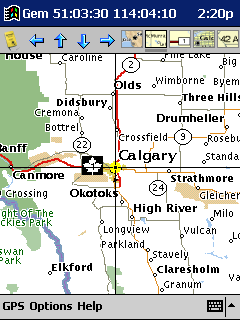
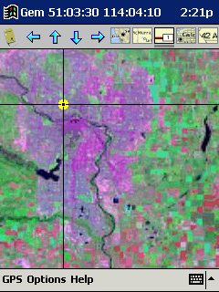
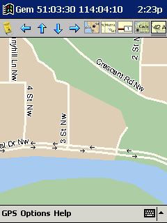
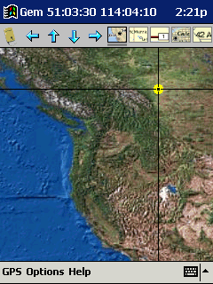
Maps, maps and mapsThis has become much easier since the days of PocketGem. GemLocal is solely using the maps of VirtualEarth (aka maps.local.live). And those are simple 256 x 256 tiles, both as maps as well as satellite images. The directory tree structure GemGlobal uses for storing its map and satellite files, is the same as used by GemGlobal. |
|
|
|
|
|

|
|
|
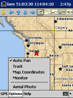
The little detailsLet's go through the menu of GemLocal, item by item.
Features that are more static in nature are set using the gem_ini.txt configuration file:
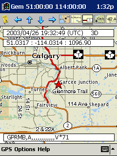
The GemLocal program will use "gem_pos.txt" to store the lat/long when it gets a first fix after starting the program. The next time the program starts, these coordinates are used to load the first map. |
|
|
|
|
|
|
|
|
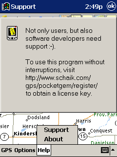
SupportThe menu option "Support" has always been my little joke with a reverse twist. It is not there to help you, but just to remind you of your side of the deal.I got many requests to develop this version of GEM for the PocketPC. To develop this program I had to invest real hard dollars in tools, books, etc. So I think it more than fair that GemLocal is shareware that will annoy you if you don't pay your fair share. As is the usual deal with shareware, try it out, see if you like it and if so, surf on to www.schaik.com/gps/gemlocal/register to get your license key. |
|
|
|